
 换一换
换一换 


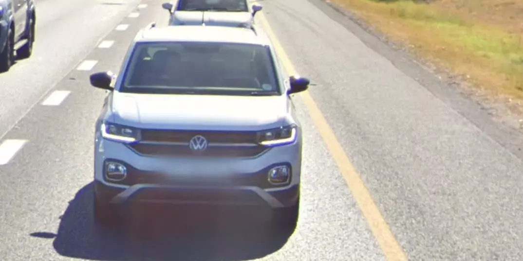
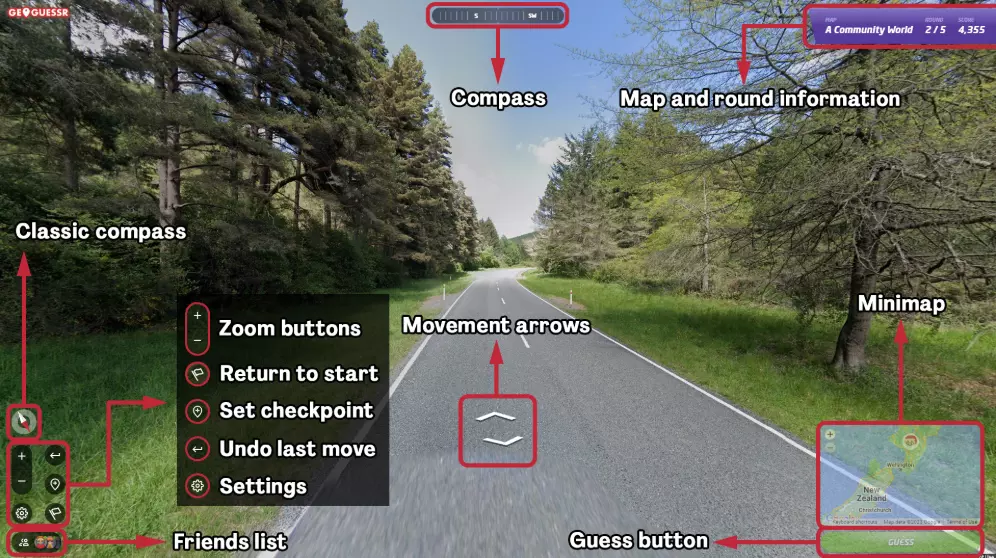
🌍 How to Win Any Game in GeoGuessr – Ultimate Guide Dominate every mode in GeoGuessr with regional tricks, meta strategies, and map-reading hacks. 🎯 Objective Your goal is to figure out where you are in the world using Google Street View. Use your surroundings to place the most accurate guess possible on the map. 🌍 Region-Specific Clues 🇪🇺 Europe • France: Yellow road signs, long D### route numbers, bollards with white tips. • Germany: Blue Autobahn signs, double reflector bollards, no license plate blur. • UK & Ireland: Drive left, yellow rear license plates, Gaelic in Ireland. • Scandinavia: • Sweden: Yellow/red signs, dashed center lines. • Norway: Blue signs, mountainous, "-en" endings. • Finland: Birch trees, flat, long vowel-heavy words. 🇺🇸 North America • USA: Yellow center road lines, green highway signs, rural mailboxes. • Canada: English/French signs, province shields (e.g., Ontario trillium). 🇧🇷 South America • Brazil: Portuguese, red soil, concrete poles. • Argentina: Blue/white signs, “RN###” roads, Andes mountains. 🇿🇦 Africa • South Africa: Left driving, Afrikaans/English mix, red terrain. • Kenya: Google car with snorkel, flat land, left-side driving. 🇦🇺 Oceania • Australia: Yellow diamond signs, left driving, red dirt. • New Zealand: Māori names, white fences, red reflector bollards. 🇯🇵 Asia • Japan: Left driving, Kanji text, black/yellow-striped poles. • South Korea: Hangul script, blue signs, clean roads. 🔍 Visual Clue Cheatsheet 📌 Driving Side • Left: UK, Australia, Japan, South Africa, NZ, Indonesia • Right: Most other countries 📌 Sun Position (for hemisphere) • South-facing shadows = Northern Hemisphere • North-facing shadows = Southern Hemisphere 📌 Language & Text • Cyrillic = Russia, Ukraine, Bulgaria • Arabic = MENA countries • Spanish/Portuguese = Latin America • French = Canada (Quebec), France, West Africa 📌 License Plates • Yellow rear = UK • Blurred = Brazil, some African countries • Long white plates = EU 📌 Road Lines • Yellow center = USA, Canada, Mexico, Colombia • White center = Europe, Asia ⚔️ Game Mode Tips 💥 Battle Royale (Country/Distance) • Guess quickly, eliminate obvious hemispheres. • Use language and flags first, signs second. • Safe guesses early → Risky plays late game. 🧠 Duels • Scan fast. Road signs and plates are gold. • Learn to bait with mid-level guesses if ahead. • Use full timer when unsure—don’t rush. 🔢 Streaks (Country/State/City) • Accuracy matters most. • Double-check text, confirm region. • Avoid clicking instinctively—analyze first. 🧠 Meta Knowledge to Learn • Common utility pole shapes • Bollard designs by region • Distinct Google car hints (e.g., snorkel = Kenya) • Common bait countries (e.g., Brazil vs Mexico, Australia vs SA) 🔧 Tools & Resources • https://www.geotips.net – Interactive guides • Plonk It[www.plonk.it] – Practice maps • GeoGuessr Reddit – Community, challenges • Rainbolt, GeoWizard – Pro YouTubers 🎉 Good Luck and Happy Guessing! If this guide helped you, leave a thumbs up! 🧭 Ultimate GeoGuessr Winning Guide 🌍 How to Win Any Game in GeoGuessr – Ultimate Guide Dominate every mode in GeoGuessr with regional tricks, meta strategies, and map-reading hacks. 🎯 Objective Your goal is to figure out where you are in the world using Google Street View. Use your surroundings to place the most accurate guess possible on the map. 🌍 Region-Specific Clues 🇪🇺 Europe • France: Yellow road signs, long D### route numbers, bollards with white tips. • Germany: Blue Autobahn signs, double reflector bollards, no license plate blur. • UK & Ireland: Drive left, yellow rear license plates, Gaelic in Ireland. • Scandinavia: • Sweden: Yellow/red signs, dashed center lines. • Norway: Blue signs, mountainous, "-en" endings. • Finland: Birch trees, flat, long vowel-heavy words. 🇺🇸 North America • USA: Yellow center road lines, green highway signs, rural mailboxes. • Canada: English/French signs, province shields (e.g., Ontario trillium). 🇧🇷 South America • Brazil: Portuguese, red soil, concrete poles. • Argentina: Blue/white signs, “RN###” roads, Andes mountains. 🇿🇦 Africa • South Africa: Left driving, Afrikaans/English mix, red terrain. • Kenya: Google car with snorkel, flat land, left-side driving. 🇦🇺 Oceania • Australia: Yellow diamond signs, left driving, red dirt. • New Zealand: Māori names, white fences, red reflector bollards. 🇯🇵 Asia • Japan: Left driving, Kanji text, black/yellow-striped poles. • South Korea: Hangul script, blue signs, clean roads. 🔍 Visual Clue Cheatsheet 📌 Driving Side • Left: UK, Australia, Japan, South Africa, NZ, Indonesia • Right: Most other countries 📌 Sun Position (for hemisphere) • South-facing shadows = Northern Hemisphere • North-facing shadows = Southern Hemisphere 📌 Language & Text • Cyrillic = Russia, Ukraine, Bulgaria • Arabic = MENA countries • Spanish/Portuguese = Latin America • French = Canada (Quebec), France, West Africa 📌 License Plates • Yellow rear = UK • Blurred = Brazil, some African countries • Long white plates = EU 📌 Road Lines • Yellow center = USA, Canada, Mexico, Colombia • White center = Europe, Asia ⚔️ Game Mode Tips 💥 Battle Royale (Country/Distance) • Guess quickly, eliminate obvious hemispheres. • Use language and flags first, signs second. • Safe guesses early → Risky plays late game. 🧠 Duels • Scan fast. Road signs and plates are gold. • Learn to bait with mid-level guesses if ahead. • Use full timer when unsure—don’t rush. 🔢 Streaks (Country/State/City) • Accuracy matters most. • Double-check text, confirm region. • Avoid clicking instinctively—analyze first. 🧠 Meta Knowledge to Learn • Common utility pole shapes • Bollard designs by region • Distinct Google car hints (e.g., snorkel = Kenya) • Common bait countries (e.g., Brazil vs Mexico, Australia vs SA) 🔧 Tools & Resources • https://www.geotips.net – Interactive guides • Plonk It[www.plonk.it] – Practice maps • GeoGuessr Reddit – Community, challenges • Rainbolt, GeoWizard – Pro YouTubers 🎉 Good Luck and Happy Guessing! If this guide helped you, leave a thumbs up!
终极《地理猜谜》获胜指南

2026-02-15 10:00:25

导读
这是一份GeoGuessr游戏的终极获胜指南,涵盖各地区识别线索,如欧洲、北美等不同国家的路牌、驾驶规则等特征,还有视觉线索、各游戏模式技巧、进阶知识及实用资源,助你精准定位,称霸GeoGuessr各模式。

评论
共0条评论

发售日期公布!
我们万分激动地(终于!)宣布确切的发售日期!《地理猜谜》Steam版将于5月8日在商店上线!冲啊!!
2026-02-13 09:000赞 · 0评论

关于免费游玩的游戏更新
业余组 此前,无限次的业余组仅对Steam创建的账户开放。我们现已发布更新,所有用户(包括关联账户)均可无限次重玩业余组! 注意:付费用户(Steam通行证或网…
2026-02-13 09:000赞 · 0评论
开发者更新 #7
大家好, 今天我们为大家带来一个重要更新。 最近,我们重新审视了《地理猜谜》Steam版的现状。基于内部讨论和玩家反馈,我们决定专注于多项改进,旨在提升Stea…
2026-03-31 07:270赞 · 0评论
《地理猜谜》终极指南——如何从“我在哪儿?”到“哦,那是博茨瓦纳农村”
🌍 GeoGuessr Ultimate Guide – How to Go from “Where Am I?” to “Oh, That’s Rural …
2026-02-15 07:000赞 · 0评论
《地理猜谜》Steam版即将上架商店!
《地理猜谜》——这款让你置身于世界某处街头并需找出所在位置的游戏,即将登陆Steam!该版本计划于4月推出,将包含排位制的单人对决以及非排位制的团队对决。我们正…
2026-02-13 09:000赞 · 0评论
2.0版本:免费快速对战!
我们很高兴宣布《地理猜谜》Steam版将迎来一系列重大改进。除了更新的导航用户界面外,敬请查看以下更新内容!
2026-02-13 09:000赞 · 0评论
《植物大战僵尸2》追击模式怎么玩?无尽模式攻略与科技满天飞问题解析,常驻模式烂完了吗?
先说比较主要的两个,追击和无尽 追击:这个模式本身做的是真的可以,是个合格的竞技模式,但现在已经被科技满天飞整变味了,现在想上榜基本没有玩家本身技术水平的因素,…
2026-05-31 01:300赞 · 14评论
沙盒游戏 留下的人_详细的萌新入坑指南[Roblox Those who remain]
补充: 燃烧物会给丧尸带来加速效果(好像?) Juggernaut只有Regular模式不会出现,萌新尽量选择regular服务器游玩。 Classic 和 h…
2025-11-06 18:090赞 · 0评论

每个关卡和每种游戏模式的完整视频攻略![已更新!]
本指南将展示如何精通每种模式下的所有关卡,涵盖战役、英雄挑战和钢铁挑战。 攻略说明: 我在自己的网站上制作了一个小型游戏地图,你可以通过点击地图来选择关卡,无需…
2026-04-05 22:000赞 · 0评论
如何在《杰克盒子调查大混乱》中赢得所有模式(百分百获胜)
我来教你如何在《杰克盒调查混乱》的所有模式中获胜!(百分百胜率) 高低猜 猜最高值!就想最棒的答案 猜最低值!随便写点东西 方块模式 让你的朋友代劳吧——如果你…
2026-03-18 10:000赞 · 0评论
暂无更多
最新更新
- 开发者更新 #7 — 大家好, 今天我们为大家带来一个重要更新。 最近,我们重新审视了《地理猜谜》Steam版的现状。基于内部讨论和玩家反馈,我们决定专注于多项改进,旨在提升Stea…
- 猜测巴西。第二部分 — 巴西指南续篇 大家好 这是巴西指南的续篇。 从自然和部分建筑的角度来介绍各地区。 地区 巴西可分为5个地区: 北部 东北部 中西部 东南部 南部
- 指南:如何成为职业电竞选手、黑客 — 如何成为局外人指南 指南 要成为专业级玩家需要多年的训练: 1. 寻找清晰的街道名称 2. 搜索该街道 完成! 或者: 1. 寻找任何文本 2. 通过图片翻译查…
- 菲律宾识别指南 — 如何在几秒钟内判断自己身处菲律宾?以下是菲律宾的几个典型特征: 主要使用英语,英语是当地的官方语言,但也可能会听到他加禄语。 热带气候和独特的植被,这里生长着棕…
- 如何成为优秀玩家 — 如何成为一名优秀玩家 步骤 1 不要搜索攻略 2 不要在两秒内随意猜测
- . — .
- 使用PLONK IT:从入门到精通指南 — Plonk It 是一个由社区驱动的网站,致力于帮助玩家提升《地理猜谜》(GeoGuessr)的游戏水平,这也适用于 Steam 版。该网站提供详细的国家指南、…
- 100%成就 | 地理猜谜 Steam版 — 这是一份完整的指南,详细介绍了获取游戏中所有成就的方法。如果你从未玩过这款游戏,或者只是想收集成就,本指南将向你展示如何全部获得它们。 可以使用浏览器的搜索功能…
- 游戏玩法说明 — 按照说明进行游戏。 完成。 说明
- 你还好吗? — 谁在玩这破游戏,你们是不是有毛病? 我服了 谁在玩这破游戏,你们是不是有毛病?