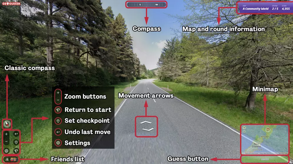
GeoGuessr Steam Edition


大家好, 今天我们为大家带来一个重要更新。 最近,我们重新审视了《地理猜谜》Steam版的现状。基于内部讨论和玩家反馈,我们决定专注于多项改进,旨在提升Steam版的游戏体验,并使其更符合玩家对《地理猜谜》游戏的期望。 目前我们暂未准备好分享具体细节,但我们对未来的发展方向充满信心,相信这些改变将为所有类型的《地理猜谜》玩家带来积极体验。 因此,在我们全力开发和完善后续内容期间,可能会相对安静一些,但大家可能会看到一些新内容逐步融入游戏中。《GeoGuessr》更新内容 1. 修复了成就无法正常运行的问题(祈祷顺利) 2. 重新启用快速对战组队决斗中的聊天功能(现已加入聊天过滤器) 3. 将快速对战地图从世界地图更新为A Figsy World


Plonk It 是一个由社区驱动的网站,致力于帮助玩家提升《地理猜谜》(GeoGuessr)的游戏水平,这也适用于 Steam 版。该网站提供详细的国家指南、新手教程、精选地图目录、竞技排行榜以及各种增强游戏体验的工具和脚本。无论你是《地理猜谜》的新手,还是希望精进技能的资深玩家,Plonk It 都能提供资源和互助社区,助你在游戏之路上不断进步。

如何在几秒钟内判断自己身处英国? - 车辆靠左行驶 - 车牌上没有蓝色矩形(英国不属于欧盟) - 欧式风格建筑 - 英语语言环境 - 网站域名以.uk结尾 - 电话区号为+44 总的来说,凭借这些因素可以轻松识别出英国,关键是不要和澳大利亚弄混,因为澳大利亚也符合上述第1、2、4点特征。


🌍 How to Win Any Game in GeoGuessr – Ultimate Guide Dominate every mode in GeoGuessr with regional tricks, meta strategies, and map-reading hacks. 🎯 Objective Your goal is to figure out where you are in the world using Google Street View. Use your surroundings to place the most accurate guess possible on the map. 🌍 Region-Specific Clues 🇪🇺 Europe • France: Yellow road signs, long D### route numbers, bollards with white tips. • Germany: Blue Autobahn signs, double reflector bollards, no license plate blur. • UK & Ireland: Drive left, yellow rear license plates, Gaelic in Ireland. • Scandinavia: • Sweden: Yellow/red signs, dashed center lines. • Norway: Blue signs, mountainous, "-en" endings. • Finland: Birch trees, flat, long vowel-heavy words. 🇺🇸 North America • USA: Yellow center road lines, green highway signs, rural mailboxes. • Canada: English/French signs, province shields (e.g., Ontario trillium). 🇧🇷 South America • Brazil: Portuguese, red soil, concrete poles. • Argentina: Blue/white signs, “RN###” roads, Andes mountains. 🇿🇦 Africa • South Africa: Left driving, Afrikaans/English mix, red terrain. • Kenya: Google car with snorkel, flat land, left-side driving. 🇦🇺 Oceania • Australia: Yellow diamond signs, left driving, red dirt. • New Zealand: Māori names, white fences, red reflector bollards. 🇯🇵 Asia • Japan: Left driving, Kanji text, black/yellow-striped poles. • South Korea: Hangul script, blue signs, clean roads. 🔍 Visual Clue Cheatsheet 📌 Driving Side • Left: UK, Australia, Japan, South Africa, NZ, Indonesia • Right: Most other countries 📌 Sun Position (for hemisphere) • South-facing shadows = Northern Hemisphere • North-facing shadows = Southern Hemisphere 📌 Language & Text • Cyrillic = Russia, Ukraine, Bulgaria • Arabic = MENA countries • Spanish/Portuguese = Latin America • French = Canada (Quebec), France, West Africa 📌 License Plates • Yellow rear = UK • Blurred = Brazil, some African countries • Long white plates = EU 📌 Road Lines • Yellow center = USA, Canada, Mexico, Colombia • White center = Europe, Asia ⚔️ Game Mode Tips 💥 Battle Royale (Country/Distance) • Guess quickly, eliminate obvious hemispheres. • Use language and flags first, signs second. • Safe guesses early → Risky plays late game. 🧠 Duels • Scan fast. Road signs and plates are gold. • Learn to bait with mid-level guesses if ahead. • Use full timer when unsure—don’t rush. 🔢 Streaks (Country/State/City) • Accuracy matters most. • Double-check text, confirm region. • Avoid clicking instinctively—analyze first. 🧠 Meta Knowledge to Learn • Common utility pole shapes • Bollard designs by region • Distinct Google car hints (e.g., snorkel = Kenya) • Common bait countries (e.g., Brazil vs Mexico, Australia vs SA) 🔧 Tools & Resources • https://www.geotips.net – Interactive guides • Plonk It[www.plonk.it] – Practice maps • GeoGuessr Reddit – Community, challenges • Rainbolt, GeoWizard – Pro YouTubers 🎉 Good Luck and Happy Guessing! If this guide helped you, leave a thumbs up! 🧭 Ultimate GeoGuessr Winning Guide 🌍 How to Win Any Game in GeoGuessr – Ultimate Guide Dominate every mode in GeoGuessr with regional tricks, meta strategies, and map-reading hacks. 🎯 Objective Your goal is to figure out where you are in the world using Google Street View. Use your surroundings to place the most accurate guess possible on the map. 🌍 Region-Specific Clues 🇪🇺 Europe • France: Yellow road signs, long D### route numbers, bollards with white tips. • Germany: Blue Autobahn signs, double reflector bollards, no license plate blur. • UK & Ireland: Drive left, yellow rear license plates, Gaelic in Ireland. • Scandinavia: • Sweden: Yellow/red signs, dashed center lines. • Norway: Blue signs, mountainous, "-en" endings. • Finland: Birch trees, flat, long vowel-heavy words. 🇺🇸 North America • USA: Yellow center road lines, green highway signs, rural mailboxes. • Canada: English/French signs, province shields (e.g., Ontario trillium). 🇧🇷 South America • Brazil: Portuguese, red soil, concrete poles. • Argentina: Blue/white signs, “RN###” roads, Andes mountains. 🇿🇦 Africa • South Africa: Left driving, Afrikaans/English mix, red terrain. • Kenya: Google car with snorkel, flat land, left-side driving. 🇦🇺 Oceania • Australia: Yellow diamond signs, left driving, red dirt. • New Zealand: Māori names, white fences, red reflector bollards. 🇯🇵 Asia • Japan: Left driving, Kanji text, black/yellow-striped poles. • South Korea: Hangul script, blue signs, clean roads. 🔍 Visual Clue Cheatsheet 📌 Driving Side • Left: UK, Australia, Japan, South Africa, NZ, Indonesia • Right: Most other countries 📌 Sun Position (for hemisphere) • South-facing shadows = Northern Hemisphere • North-facing shadows = Southern Hemisphere 📌 Language & Text • Cyrillic = Russia, Ukraine, Bulgaria • Arabic = MENA countries • Spanish/Portuguese = Latin America • French = Canada (Quebec), France, West Africa 📌 License Plates • Yellow rear = UK • Blurred = Brazil, some African countries • Long white plates = EU 📌 Road Lines • Yellow center = USA, Canada, Mexico, Colombia • White center = Europe, Asia ⚔️ Game Mode Tips 💥 Battle Royale (Country/Distance) • Guess quickly, eliminate obvious hemispheres. • Use language and flags first, signs second. • Safe guesses early → Risky plays late game. 🧠 Duels • Scan fast. Road signs and plates are gold. • Learn to bait with mid-level guesses if ahead. • Use full timer when unsure—don’t rush. 🔢 Streaks (Country/State/City) • Accuracy matters most. • Double-check text, confirm region. • Avoid clicking instinctively—analyze first. 🧠 Meta Knowledge to Learn • Common utility pole shapes • Bollard designs by region • Distinct Google car hints (e.g., snorkel = Kenya) • Common bait countries (e.g., Brazil vs Mexico, Australia vs SA) 🔧 Tools & Resources • https://www.geotips.net – Interactive guides • Plonk It[www.plonk.it] – Practice maps • GeoGuessr Reddit – Community, challenges • Rainbolt, GeoWizard – Pro YouTubers 🎉 Good Luck and Happy Guessing! If this guide helped you, leave a thumbs up!


如何在几秒钟内判断自己身处菲律宾?以下是菲律宾的几个典型特征: 主要使用英语,英语是当地的官方语言,但也可能会听到他加禄语。 热带气候和独特的植被,这里生长着棕榈树和其他热带植物。 城市的混乱与贫民窟并存。这里城市的各个区域对比鲜明,尤其是首都马尼拉。马尼拉的典型特征是有非常多的电线和摩托车,以及贫民窟中的摩天大楼。网站域名是.ph,电话区号是+63。如果能看到相关标牌,那你就很幸运了。总的来说,主要是遵循这些要点,不要与东南亚其他国家混淆,通常如果出现菲律宾的场景,大多数情况下就是马尼拉。


1. 初印象 看到柏油路了?恭喜,你现在位于世界上195个国家中的一个。 有树?太好了,这一下就把范围缩小到了地球的80%。 2. 地图移动 点击到一公里外的地方——结果还是一样糟糕。 放大标记,直到像素变成你对现代艺术的诠释。 3. 地点猜测 不知道?选巴西吧。通常都是巴西。 看起来像美国?那肯定是澳大利亚。 4. 进阶技巧 学会“元区域”:如果是草地,那可能真的是任何地方。 如果你看到西里尔字母的文字,猜俄罗斯……然后发现其实是蒙古。 5. 心理与策略 限时游玩。压力和恐慌会让准确率整整降低15%。 不知道的话,就点击地图正中央。你至少有一种心理上的感觉,觉得自己离目标很近。 结论: 《地理猜谜》是一款将你的世界知识变成随机点击模拟器的游戏。 作者:Kab1q,职业“我到底在哪儿?”玩家。

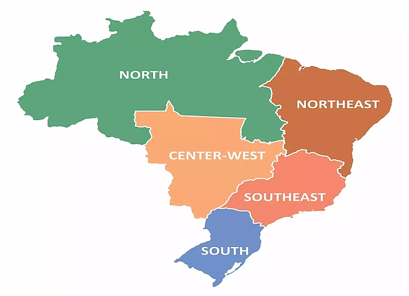
🌍 GeoGuessr Steam Edition A Complete Country Identification Guide With Chapters, Key Clues & Practical Tips 📖 Chapter 1: GeoGuessr Steam Edition – How the Game Works GeoGuessr (Steam Edition) drops you somewhere in the world using Google Street View. Your goal is to figure out where you are using visual clues. You must rely on: Roads Signs Language Nature Architecture Cars Poles License plates Road markings Camera quality & meta clues Unlike browser versions, Steam Edition often: Uses competitive modes Has time limits Requires faster recognition Rewards pattern knowledge 🧭 Chapter 2: Core Skills Every Player Must Learn Before countries, you need fundamental skills: 🔎 Always Look For (in this order) Side of the road (left or right driving) Language / alphabet Road lines Landscape & climate Poles, signs, bollards Cars & plates Google car meta Mastering these turns guessing into deduction. 🌎 CONTINENT & COUNTRY CHAPTERS 🇺🇸 Chapter 3: United States Key Indicators Yellow center lines White outer lines Large roads & highways Wooden utility poles Big cars English language Landscape Clues Desert → Southwest (Arizona, Nevada) Green hills → East Coast Flat farmland → Midwest Mountains & pine trees → Northwest Street View Meta Older camera quality Car visible sometimes 🇨🇦 Chapter 4: Canada Key Indicators Similar to USA but: French + English signs Red/white signs Speed in km/h Snow poles in rural areas Province Clues French only → Quebec Flat prairie → Saskatchewan / Manitoba Mountains → British Columbia 🇲🇽 Chapter 5: Mexico Key Indicators Spanish language Concrete poles with holes Speed bumps everywhere Colorful buildings Dry or tropical climate Meta Google car antenna visible Sun often high 🇧🇷 Chapter 6: Brazil Key Indicators Portuguese (not Spanish!) Blacl-and-white poles Red dirt roads Tropical vegetation Concrete houses with flat roofs Road Clues Yellow outer lines White center lines (often) 🇦🇷 Chapter 7: Argentina & Uruguay Shared Clues Spanish language European-style cities Flat grasslands Differences Argentina: Vast empty roads Long distances Uruguay: Smaller roads More greenery 🇬🇧 Chapter 8: United Kingdom & Ireland UK Driving on the left Yellow rear plates White front plates Brick houses Hedge-lined roads Ireland English + Irish (Gaelic) Narrow roads Rural feel Speed signs in km/h 🇫🇷 Chapter 9: France Key Indicators French language White road signs European architecture Blue town signs Meta Black tape on poles sometimes Rural areas very distinct 🇩🇪 Chapter 10: Germany Key Indicators German language Yellow town signs Clean infrastructure Red roof houses Autobahn signs 🇪🇸 Chapter 11: Spain Key Indicators Spanish language Dry climate White buildings Red/orange soil Black bull signs sometimes Bollards White with black top 🇮🇹 Chapter 12: Italy Key Indicators Italian language Stone houses Narrow streets Curved mirrors Blue road signs 🇸🇪 🇳🇴 🇫🇮 Chapter 13: Scandinavia Shared Clues Yellow center lines White road edges Pine forests Reflective bollards Differences Sweden: red houses, flat Norway: mountains, fjords Finland: very flat, birch trees 🇵🇱 🇨🇿 🇸🇰 Chapter 14: Eastern Europe Poland Polish language (ł, ą, ę) Flat roads Red brick buildings Czech Republic Diacritics (č, š, ž) Forested hills Slovakia Similar to Czech but more mountainous 🇷🇺 Chapter 15: Russia Key Indicators Cyrillic alphabet Rough roads Soviet-style buildings Birch trees Long straight roads Meta Old camera quality Car hood sometimes visible 🇯🇵 Chapter 16: Japan Key Indicators Driving on the left Japanese characters Yellow/black poles Narrow roads Dense wiring 🇰🇷 Chapter 17: South Korea Key Indicators Korean Hangul Blue road signs Clean streets Urban density 🇦🇺 Chapter 18: Australia Key Indicators Driving left Dry climate Red soil Long empty roads White guide posts 🇿🇦 Chapter 19: South Africa Key Indicators Driving left English + Afrikaans Yellow road edges Mountains or savannah Metal guardrails 🌍 Chapter 20: Africa (General) Kenya Snorkel Google car Red soil Acacia trees Ghana Black tape on poles Tropical greenery Tunisia Arabic + French Dry Mediterranean climate 🧠 Chapter 21: Meta Clues (Advanced) Google Car Snorkel → Kenya White hood → Nigeria Blurred roof rack → Senegal Camera Quality Old → Russia, Mongolia New → Western Europe 🏁 Chapter 22: Final Tips for Steam Ranked Play ✔ Learn patterns, not countries ✔ Move less, observe more ✔ Practice continent guessing first ✔ Use elimination logic ✔ Don’t panic — clues repeat

如何成为局外人指南 指南 要成为专业级玩家需要多年的训练: 1. 寻找清晰的街道名称 2. 搜索该街道 完成! 或者: 1. 寻找任何文本 2. 通过图片翻译查看是什么语言 3. 猜测国家(有猜错的风险) 完成!


好的,很高兴你能来,这是我的一些实用技巧,都是干货,我可是这款游戏的绝对大佬,相信我,好了,我们开始吧 1 - 你在亚洲,看到干净的街道,那很可能是日本;如果你看到丰田车,那100%是日本。 2 - 车上有黄色牌照,而且看起来像欧洲,那不是英国就是荷兰;如果看起来不像欧洲,那问题就来了。 3 - 环境很脏?有西班牙语标识?那就是拉丁美洲了,不过我不太确定“拉丁美洲”这个叫法对不对,或许我该查一下,算了,反正那里说拉丁语系的语言,这么说也有道理。 4 - 还有什么呢……嗯,如果有英文和汉字标识,那很可能是台湾,或者是香港。 好了,以上就是我的经验之谈,希望能帮到某些人,祝你们好运,会用得上的。